Monday, July 18, 2011

Day 4 - 27 June 2011 - Onward to Leh (Sarchu to Leh)

7am - Woke up several times last night. There was a moment in time when I thought I was going to suffer from a bad bout of fever. Luckily, I felt better after removing my outer layer and my knitted head wear. It was pretty hard to navigate under a thick blanket in such rapidly changing weather (or an overheating body!). As I head outside, we could see the marmots out in full force behind our tents, wrestling each other. Time for breakfast and onwards we go!

Marmots behind our tents!
The marmots were really unperturbed by our presence to wrestle with each other!
Goldrop's luxurious tents - really luxurious!
Another one of those stops
12pm - stopped at Pang for lunch. Before that, we traversed the Gata Loops up to Nakli Pass which was about 4950m high. The Loops were a series of 22 hairpin turns and the ascent was rapid. I sure wouldn't want to be suffering from AMS now! Unfortunately, our driver, Vippin, seems to be suffering badly from it. Jo already had a mild bout of it and so did Racheal last night. The harsh altitudes and huge change in temperature weakens the body but thankfully, not so bad as to affect the mind.

mountain edged roads
A little hard to imagine greenery here but the valleys here can be bustling with life
a bridge that you can't help but be extremely careful with. One at a time!
Gata Loops - as enjoyed by an Enfield
Dear's at the Gata Loops!
leaving our marks at Lachulang La.. :P
Milestone with prayer flags at Lachulang La (~5000m)
But not before passing through Nakeela Pass (~4800m)
Broke-backing at Lachulang La
List of the passes along the Manali-Leh Highway at Tanglang La
Tanglang La - The second highest motorable road in the world! (~5330m)...and I pee-d there!
Vippin suffers from AMS and clearly isn't too amused with the crazy bunch of Singaporeans running about in Tanglang La
the good ladies at the foot of Tanglang La - the second highest motorable road in the world.  With lots of vegetables and some medicine for Vippin, I'm sure he must have felt comforted.
After Nakli Pass, we descended for a while but went up to 5065m to Lachulang La. Here the view was breathtaking, figuratively and factually speaking! Climbing down a steep slope would cause one to pant for a verrrrry long time. Along the way to Pang, we also saw the Border Road Organization (BRO) workers working hard to ensure the pass was passable to traffic (see below on what BRO stands for).  Imagine using basic tools like a hammer and a pick, they clear the roads of landslide debris and rest by the roadside without shelter from the relentless sun. Looking at their weathered faces and yet wide smiles, we can only admire and salute their selfless efforts in this harsh environment. They had to even ask passing vehicles for water!

A BRO worker resting without shade in the scorching, relentless sun
More BRO workers, this time with a scenic view but with the same intense sun
They work in groups and lie on the fields to rest. With no water supply, they must ration for the day
These thirsty workers asked for water. This is a terrible day job.
Once in a while, a landslide occurs and these guys turn up, making sure the roads are clear for you...and more importantly, the Army. These roads lead to the highest battlefields in the world at Kargil and Pangong Tso (which we'll be riding to in a couple of days)
1pm - we are now at the Moreh Plains, a vast expanse of dust and occasional vegetation at 4723m high according to my GPS. Just one more Pass to cross but also the highest of all in the journey to Leh, at an altitude of 5350m high. To get a sense of perspective, the altitude is at Everest Base Camp level, before climbers attempt their arduous ascent to Everest.

1145pm - the roads to Leh start to get exciting again after the stillness of the Moreh Plains as we began our ascent to Tanglang La, the second highest motorable road in the world. Breathing became obviously more difficult as the sea-level dwelling creatures could get use to the oxygen deficient rarefied air. Needless to say, we spent a short time there before heading back to our car to recover and catch our breath.

A bridge milestone with the name of the bridge and sometimes, warning signs
The journey to Leh continues as we struggle to recover from the high altitude pass. The condition of the roads did not make it any easier. What were roads 2 years ago became rubble as a rare cloudburst last year caused massive erosion. We had to wait for the BRO workers to blow up a landslide before we could even pass. Through this journey, my impression of these workers also changed. While I had thought they only use basic tools earlier, the more complicated road repairs made use of the grouting method to strengthen the rocks beside the roads and heavy machinery to remove debris quickly.


Explosive power used to blow up a landslide - not far from Leh now!
the roads to Leh are crusty, dusty and beautiful. The Silk Road travellers of yonder must have longed to get to Leh after a long, hard journey.
Besides spoilt roads, we had to wait for huge army convoys to pass through a single lane. To make it even more challenging, our rear left tire sprung a puncture while thrashing through one of the numerous water pools left behind by melting glaciers.

the beauty of nature and the insignificance of men.  Look closely and you'll see a long line of trucks.
only one way traffic for now!
So we came down to take some pictures
An unfortunate truck with an excavator onboard (probably BRO's) gets stuck along the highway.
and immediately after passing the truck, we get a puncture!
How nice...:)
Not a really bad place to get a puncture.
Another road obstacle to get through
 After numerous checkpoints where we had our passports checked, we noticed big army camps in the region, indicating the sensitive border issue with several neighbouring countries. We reached Leh at 640pm and jostled with the evening traffic and the confusion created by one way traffic of the roads. Eventually, Isaac managed to speak to Tundup, our POC in Overland Expeditions, and headed to our lodgings in Leh. Over the next few days, Leh will become our base as we head out to the various sites around the region on both car and Royal Enfields. Boy oh boy, I can't wait!

The Border Roads Organisation is a symbol of Nation Building and National Integration and has become an inescapable component in maintaining the security and integrity of the Nation.  Its pivotal role in constructing and maintaining operational road infrastructure for the armed forces in inhospitable, far flung border areas and contribution to the socio-economic development of the region has been legendry. Its ability during war has been repeatedly proven.  This is the result of over 50 years of toil, unwavering dedication, unmatched professionalism and sacrifice of the officers, supervisors, subordinates and CPLs, from whom the organisation derives its strength.- www.bro.gov.in

BRO's ongoing project in Ladakh is HIMANK and they are really well-known for their humourous road signs in exceptional scenery.

http://en.wikipedia.org/wiki/Himank


A bridge milestone with BRO's logo
"Welcome to the Paradise of India" indeed!
"It's always better to be Mr Late than the Late Mr"
"Virgin Nature of Ladakh is the Art of God"
"Peep Peep. Don't Sleep!" - the roadsign that a coffeetable book of indian roadsigns was named after
"Don't be Gama in the Land of Lama" - Gama means proud in Ladakhi
"Drive on Horsepower, not on Rum Power"
"Blind Curve Ahead, Check Your Nerve"
:)
 

Day 3 - 26 June 2011 (Keylong to Sarchu)


730am - bright and early today. In fact, daybreak is at about 5am but the thick blanket was way too comfortable to give up. There didn't seem like there was going to be a morning market from our evening walk last night so we didn't bother to rouse ourselves too early from sleep. :) 
breakfast with our regular eggs and toast but sweetened by Kashmiri cherries
Remnants of tea the night we arrived
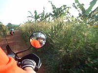
 1045am - we're on our way to Sarchu now and the roads don't get any better. The dust was getting from bad to worse. Last night was spent trying to dust away the dirt and dust from our gear but to no avail. You see, when we are at such a high altitude, it is a crime to not wind down the windows and get the cool mountain air. The only problem is to deal with the dust kicked up by the oncoming veh or the one in front. We are dealing with it like the Afghanistan soldiers, with scarves draped round our mouths and we end up looking like a car full of bandits!
Vippin loading our luggage in the morning
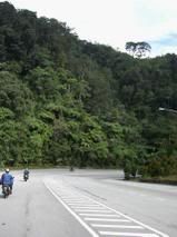
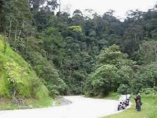
good roads and even lesser vehicles
Sign to Darchu
Can't resist shop signs
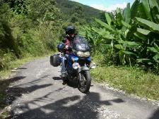
the scenery changes (brownery instead of greenery) as we hit further north
So far, the roads seem to be a mixture of tarmac and gravel. I don't know what I want, the tarmac or the gravel.

1115pm - where do I begin to start?! I'm all snuggled up with 4 layers of clothings, under 2 layers of blankets and hugging a hot water bottle and im shivering as hell. More on that state later. The roads were mostly gravel all the way to Sarchu but many cars before us got stuck at 2 river crossings which proved treacherous for bikers on this highway. When we arrived at the first crossing, there were already some bikers with rubber boots assisting some stuck cars. Isaac remembered this place very well for this was where he almost suffered from hypothermia trying to push a biker across 2 years ago. The waters were actually melted glacier waters not very far from where we were.
Zingzingbar - signs that the roads are not going to be easy
Bikes stop at a river crossing as the French bikers help the cars get across
Yep, the cars are really stuck and the sound the gushing waters make is not comforting at all if you are the driver
the passengers of the car sit and watch as the car tries to get across

the truck to the rescue! - though it took several failed tries.  The French bikers were really into helping the folks out but Isaac knew better - 2 years ago, he did the same and his feet got badly frozen stiff. The bikers are going to regret this big time though they'll have a story to tell afterwards!


A video on how the bikers got across

After all the work, Mother Nature reminds us that it that we are all insignificant in her eyes
Those bikers managed to get one car across but the 2nd one took almost 15 min with the assistance of a truck to pull the stranded car out! The bikers were almost shell shocked with the cold waters by then but continued to labour on. The more experienced drivers who ply this route often wisely stayed out of the waters and instructed the poor guys already in the water and all this while, we were filming. :)

We had also passed the Baralacha Pass at 4400m and the snow was a great joy for all of us and we headed down to Darcha for a hot lunch as the weather was starting to get really cold.
Stopping at Baralacha La
Really chilling out here
A nearly frozen lake in the summer
Photographing snow flakes
Cs considered opening a shop here
A real dhaba at Darchu where we had our first Maggi Mee and masala chai combination. We never turned back from this combination again..
As we continued on our journey, we came to the second heavy river crossing. The second one seemed tougher as the crossing was longer and of all cars plying the route, a volkswagen polo got stuck in the middle. It was also pulled out but probably with a damaged undercarriage as the car slammed into a steep climb.
A Volkswagen Polo going where he isn't meant to go
that's right - pull her up!
Again, this is but just a small stream in life's journey
But with people and drivers stopping and helping each other, we'll all pull through somehow.
After clearing this, we reached our tents for the night, Goldrop Tents, which promised luxurious rooms with basic amenities. We even have attached toilets in our tents. We have to watch our flushing of the toilet though as the cistern does not fill up automatically as we were in the middle of a deserted valley! The plains were A wonderful sight with short green grass and flowers everywhere. We couldn't resist but to have a tea picnic with our packed lunch.
picnic-ing out in the cold, but skin's frying in the sun!
Enjoying our packed lunch at about 4pm
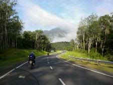
The road to Leh is still long - ~ 250km more!
Dear discovered a marmot!
Luxurious camp indeed!
We're going to sleep at an altitude of 4385m
Us with the Zanskar Range looming in the background
We had also sighted numerous wildlife of the area such as the Himalayan pigeons and the marmots, which looked like giant guinea pigs on the plains. There were several Marmot tunnels behind our tent and we spent some time exploring these entrances hoping for a head to pop out!

This was also when the temperatures dropped rapidly and the heavy winds winds compounded the problem. Dinner was done with heavy layers of clothings and thankfully so, as the winds picked up outside as we were having our dinner in the dinner tent.

This was also when we decided to shoot star trails as the valley sky was choked full with them. So, in temperatures of abt 1 or 2 deg, Isaac, Cs, racheal and myself braced ourselves for the shoot but Cs and Racheal soon fell out as the freezing temperature weren't doing any good. So here i am, shivering my butt off, but glad I finally got the one shot I always wanted to try - though it was still a blurry shot!
my best attempt at a star trail
Time for bed but seems like a long night for some cos I hear some people having severe vomitting in the tents opposite us. I'm so glad I took my acute mountain sickness pills this time round.

The route from Manali to Leh - If you're interested, just follow the map from Manali to Leh!